Heritage Policy
The protection of historic resources requires enabling legislation, policies, bylaws, incentives, and citizen engagement. In 2020, the City of Calgary greatly added to its toolkit for heritage conservation while revamping its process for planning for growth in developed communities. Learn about these new initiatives, the tools that have been in place for some time, and how other cities protect their heritage.
Districts with Heritage
Policies for Heritage Districts
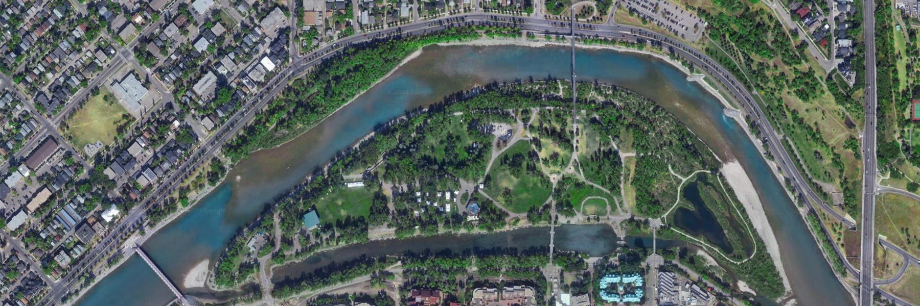
What makes a heritage district? Areas with a sense of history, where historic characteristics dominate might qualify for heritage district status. The whole is greater than the sum of its parts. Together, the buildings, the parks, the streetscapes, the architecture, the materials, the human and natural history are what make a heritage district. Preservation efforts succeed best when they build upon foundational planning principles that address landscape, architecture, and social living together, respecting the spirit of place.
Legal protection of heritage districts is increasing around the world. Most major cities in Canada (Montreal, Halifax, Winnipeg, Edmonton, Ottawa, Toronto, Vancouver) encourage conservation through the use of heritage district/area bylaws. Toronto has dozens of districts protected or in the process of being designated. Winnipeg recently protected its first residential area, with more in the works.
Alberta’s Historical Resources Act allows for the designation of historic districts at both the provincial and municipal levels. Neither form of designation has been used extensively. Policies and procedures have not yet been established to help guide these protective measures. The two Provincial Historic Areas (Old Strathcona and Fort McLeod) established boundaries for the areas, but management and protection of the area remains with the municipality. While the Historical Resources Act does allow the province to enact regulation to manage the area, this has not been pursued to date.
Municipal Historic Area designations can be approved by municipal governments. There are a handful of Municipal Historic Areas in Alberta, all of which are limited to municipally-owned lands.
Owner consent is required to register any sort of regulation against private land. Both private and publicly held lands can be included in a heritage area designation. The determination of what lands are to be included is informed by the heritage values and character-defining elements of the area. Under the Historical Resources Act, municipalities must compensate owners for any loss in economic value resulting from designation. This requires negotiations with property owners and creates a challenging situation for designating historic districts that may include numerous privately-owned properties.
As of July 2020, Calgary Council directed the implementation of heritage area policy tools, including the use of direct control (DC) bylaws on a block face with at least 50% heritage assets amongst its buildings and where the majority of property owners consent to the proposed DC. While these DC bylaws for residential streetscapes are a promising first step, there is still significant work to be done by City Heritage Planning, the Government of Alberta and heritage advocates to enable designated heritage districts to exist in this province.
In other provinces, heritage districts protect elements on both public and private lands within a defined area boundary, including:
- Public parks and landscaping
- Architectural details such as roof pitch, window placement, and porches
- Height, massing and density of new development
- Patterns of streetscape such as setbacks, sidewalks and fencing on main streets, boulevards and roads
- Heritage trees and landscaping patterns
- Buildings for residential, commercial, institutional and industrial uses.
The main benefits of heritage districts are:
- Planning: to ensure that future development compliments the character of the neighbourhood or district.
- Environmental: districts encourage the retention and continued use of existing buildings thus reducing demolition, landfill waste and greenhouse gas emissions from new builds.
- Economic: research shows that property values tend to rise in heritage districts because they offer stability and predictability that make owners more confident to buy and improve properties in the area. Citizens throughout the city, as well as tourists, are more likely to visit and patronize areas with distinctive historic character. (See references below.)
Calgary has many informal heritage “districts”, some with clusters of historically significant and designated buildings, concentrated in about 10% of Calgary’s some 200 communities.
Explore some examples of protected heritage districts from other cities.
FAQs
A defined area that is legally protected to manage and conserve heritage resources within its boundary. Each province has unique legislation that enables and/or limits a municipality’s policies for the protection of heritage districts. These are sometimes called ‘heritage conservation areas’ (e.g. British Columbia) or ‘heritage conservation districts’ (e.g. Ontario). Calgary does not yet have any municipally designated heritage districts, whereas Edmonton has created a ‘heritage character area’ for Glenora. In Alberta, the Historical Resources Act specifies the legislative authority that municipalities have to create historic districts.
The word ‘district’ may also be used to identify a particular neighbourhood or commercial area, like the ‘warehouse district’ or the ‘design district’ in the Beltline, Kensington’s ‘shopping district,’ 17th Avenue’s ‘retail and entertainment district’ or the historic ‘Mission district.’ Used in this manner ‘district’ does not imply protection.
The designation of a heritage district allows for the regulation of character-defining elements that tie together an area. Each heritage district is unique, and so are its protections. Heritage districts do not necessarily impact individual houses. But, they often introduce guidelines for improvements and new developments that are compatible with the goals of preserving the character of the area. Property owners within the affected area must give consent to a designation by municipal bylaw that would be registered on title of each affected property within the district. Patterns of development on either side of area boundaries often become increasingly different after the designation of a heritage district is established.
An individual’s ability to sell or buy a building located in a heritage district is unaffected. The designation of heritage districts is generally good for property values. The largest study of its kind in North America, conducted by the University of Waterloo Heritage Resource Centre, found that homes in heritage conservation districts (HCDs) consistently perform as well as, or better than, the market trend in non-designated neighbourhoods. Properties in heritage districts tend to fare better on the real estate market because supply is limited. Also, when the quality and character of a heritage district is protected, a sizeable subset of the property market will display confidence by paying a premium to own property there.
The City’s Heritage Planners and eligible property owners work together to identify and discuss the character-defining elements that could be regulated for an historic area. The elements to be regulated would be specified in a bylaw and registered on land titles. Improvements and new developments would then have to be compatible with the goals of preserving the character of the neighbourhood.
Further Reading on the Economic Benefits of Heritage Districts for Property Owners:
Civicplan. 2017, July 18. The Economic Value of Heritage. Civicplan’s Urban Insights Bulletin.
Hulley, Richard. 2016, Nov. “The Rise of Heritage Conservation Districts,” OREA Newsletter.
Lowe, Shirley. 2017. Measuring the Value of Heritage Preservation in Edmonton.
Rypkema, Donovan. 2013. “Heritage Conservation and Property Values.” In: The Economics of Uniqueness: Investing in Historic City Cores and Cultural Heritage Assets for Sustainable Development, edited by Guido Licciardi and Rana Amirtahmasebi, 107–42. Urban Development Series. Washington, DC: World Bank Publications.
Shipley, Robert and Kayla Jonas Galvin. 2009. “Heritage Conservation Districts Work,” University of Waterloo.
Streetscapes with Heritage
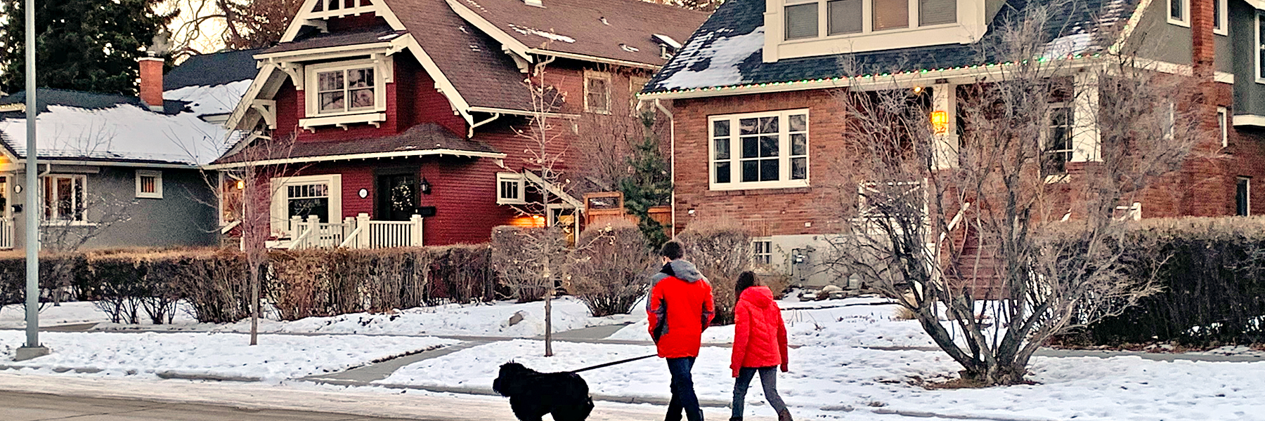
What makes a good street? What are your favourite streets in the city? Why? Policies for Streetscapes with Heritage
In July 2020, City Council approved a two-year program (2021-2023) to implement “heritage area policy tools” that will provide incentives to retain Calgary’s historic streetscapes. The program considers residential block-faces, that is one side of a street between two street corners or other geographic boundaries. The level of control exercised is relative to the percentage of heritage assets found on the block face:
- where 25%–49% of properties on one side of a block are heritage assets: design guidelines apply to all properties (including non-heritage) within the identified streetscape, implemented through a local area plan. All new construction is discretionary, requiring design review.
- where 50% or more of properties on one side of a block are heritage assets: eligible as a direct control district (requiring “majority” owner consent) defining mandatory restrictions and allowances for properties (including non-heritage assets).
These discretionary or mandatory guidelines could relate to massing, roof pitch, windows, setbacks or materials, for example. A heritage asset is defined as a residential building generally constructed prior to 1945 with historic stylistic architectural value, substantially retaining original design and features, and reflecting a pattern of historic development in an area. Notably, heritage assets may not qualify for the Inventory as an individual property. Their heritage significance is tied to them being part of a concentration of similar sites.
Read more about Calgary’s “heritage area tools and incentives” tools to protect streetscapes.
Beautiful streetscapes are more than just rows of carefully placed, distinctive homes. In the early 1900s, William Pearce developed a vision for Calgary where natural features would be protected, and he emphasized the benefits of trees and parks in the urban environment. William Reader, in his role as Calgary’s parks superintendent (1913-1942), furthered Pearce’s vision. His legacy endows us with extensive boulevard plantings, influenced by the City Beautiful movement. Reader also developed some of Calgary’s most beloved parks, including Central Park, Prince’s Island, and Riley Park.
Reader’s horticultural expertise, reflected in boulevard and median plantings, have endured and delighted for over 100 years. Original plantings on tree-lined streets still exist today, found in some of Calgary’s oldest neighbourhoods: Bridgeland, Cliff Bungalow Mission, Crescent Heights, Elbow Park, Elboya, Hillhurst, Inglewood, Mount Royal, Ramsay, Rosedale and Scarboro. There are 27 streetscapes listed on the Inventory, which were identified in Reader’s work plans. Crews that worked with Reader likely continued planting on adjacent streets, but only the streets with historical documentation have been designated, Garden Crescent being the first one. “Calgary’s street trees are now recognized as one of her greatest assets in point of beauty.” The Calgary Parks department has laid out a conservation plan for these historic streetscapes called “Conserving Calgary’s Historic Streets.”
FAQ
All the elements that make up the physical environment of a street and define its character. These elements include paving, sidewalks, trees and vegetation, lighting, building type, fencing, setback of buildings, etc. Historic streetscapes have garnered significant attention lately, with the approval of heritage policies to protect historic streetscapes in July 2020. Within part 4, see heritage area policy for historic residential streetscapes.
The City of Calgary defines a heritage asset “as a privately owned structure, typically constructed before 1945, that significantly retains its original form, scale, massing, window/door pattern and architectural details or materials. Individual heritage assets may not warrant inclusion on the inventory.” Their heritage significance may be tied to them being part of a geographic concentration of similar sites.
A visual survey of possible heritage assets in an area identified according to specific criteria of historic architecture and design. It’s called a windshield survey to give the idea that an area can be quickly surveyed through the windshield of a car. In practice, the survey is completed after properties are checked by walking the streetscape and scrutinizing individual properties. This best-practice approach follows examples such as Los Angeles’ SurveyLA program. In 2019, Calgary commissioned a windshield survey to identify potential heritage assets in 26 communities. More than 4000 historic properties were identified, many of which are clustered in what could then be identified as heritage areas.
The department of Calgary Parks has identified 27 historic streetscapes in some of Calgary’s oldest communities that retain significance due to their original plantings. Patterns of elm trees and lilac shrubs, for example, can become the object of protection. These 27 streetscapes have been evaluated by Heritage Calgary and were added to Calgary’s Inventory of Historic Resources. Calgary Parks has a plan to ensure the long-term conservation of trees for future Calgarians to enjoy.
A unique set of rules and uses defined for land parcel(s) that are unavailable in other land use districts. Parcels that have unique characteristics, unusual site conditions or innovative design might require special regulations. A direct control district can be used to protect character-defining elements for heritage streetscapes, for example. Elements to be regulated might include: building setbacks, heights, reduced parking, accommodation for alternate uses, and specific architectural controls.
When heritage assets exist in a concentrated grouping, as identified through a local area plan, then all residential properties on the identified streetscape are eligible for protections. Calgary’s heritage area policy applies to residential block-faces. A block-face is one side of a street between two street corners or other geographic boundaries. If 25% heritage assets are identified on a block face: all new construction is discretionary, requiring a design review, which applies to all properties (including non-heritage). If 50% heritage assets exist on a block face: mandatory architectural controls and regulations could apply to all properties; involving the creation of a “direct control district” with owner-consent; the highest level of control offered.
Property Designation
Municipal Designation of Private Property
Why would anyone want to designate their property as a municipal historic resource? What’s in it for me? For people who choose to designate, it usually boils down to a pride, a sense of stewardship and a love for heritage. Designation helps ensure that future generations have ties to Calgary’s past by interacting with historic buildings. You would be doing your part to help maintain the character of an historic area. You would also be contributing to environmental sustainability by preventing demolition, thereby reducing landfill and greenhouse gas emissions.
From an investment perspective, designation makes sense because it can help to offset some of the financial burden of owning an older home. The funds available through The City’s Historic Resource Conservation Grant Program assist property owners in addressing certain issues that can accumulate over the years with an older structure. All funding is offered as a matching grant. The Province also offers a Heritage Preservation Partnership Program.
In 2022, a new residential tax credit for designated properties will be considered by City Council as part of 2023-2026 budget deliberations. Depending on the area and specific property conditions, additional incentives may be available for designated heritage sites, including density transfers and bylaw relaxations (for more information, see links below).
It’s important to note that protection only applies to certain parts of a heritage building, as agreed to by the designating property owner. Perhaps the porch of a Craftsman home or the board-and-batten on a Tudor-Revival are deemed to have historic significance. However, original fir floors that can’t be refinished could be excluded. Non-historic elements are typically excluded from designation. Once designated, the owner and the future purchaser are not able to demolish, and cannot significantly alter the regulated portions without City approval. The building could change in use, however, and additions are permitted as long as the designated elements are retained.
Would designation make my property less attractive on the real estate market? Research shows that in some markets, designated heritage homes can actually increase in value faster than other properties and hold their value during market slumps. The limited supply of heritage homes can make them a particularly desirable asset to certain buyers, giving them a unique position in the real estate market.
First Steps – the Inventory of Evaluated Historic Resources
The first step in designating your property is contacting Heritage Calgary to express an interest in having your property evaluated and added to the Inventory of Evaluated Historic Resources. Have you ever wondered about the history of your building? Who built it? Who lived or worked there? This information will be uncovered during the evaluation process.
The Inventory is maintained by Heritage Calgary, a Civic partner of the City of Calgary, led by a Council-appointed Board. To date, nearly 900 heritage sites have been evaluated and are formally acknowledged to have significant heritage value, with more added each year. About 11% (just over 100 sites) are protected by the City and another 5% by other levels of government.
To learn more about the designation of historic properties in Calgary, check out the following resources:
1. Heritage Calgary’s step-by-step process
2. Calgary Heritage Initiative’s past presentations on ‘Demystifying Designation’
3. City of Calgary Heritage Planning overview of the designation process
4. Government of Alberta Heritage Preservation Partnership Program
To find out more about incentives related to the designation of historic properties:
1. Funding through the City’s Historic Resource Conservation Grant Program
2. Funding through the Province’s Heritage Preservation Partnership Program
3. Density transfers and bylaw relaxations, along with other incentives
To learn about personal designation stories in Calgary, click here.
Photos of designated properties courtesy of the Inventory of Evaluated Historic Resources (calgary.ca)
FAQs
Heritage resources include: "buildings, bridges, engineering works and other structures; cultural landscapes such as historic parks, gardens or streetscapes; culturally significant areas, including indigenous traditional use areas and sites with archaeological or palaeological significance. These can be managed by municipal, provincial or federal authorities." (City of Calgary). Buildings, landscapes and features that are at least 25 years-old and have standalone significance, may qualify for listing on the City's growing inventory of historic resources. They are evaluated by Heritage Calgary, a civic partner, according to a Council-approved evaluation system. When listed on the inventory, historic resources are recognized for their heritage significance and are referred to as heritage sites. Historic resources are not subject to development or demolition restrictions unless designated (legally protected) in cooperation with a property owner. To access Calgary's Inventory of Evaluated Historic Resources, click here. Other inventories exist for federally and provincially recognized historic places. Once an evaluated historic resource on the Inventory becomes municipally designated by a Council-approved bylaw, it is legally protected under the Alberta Historical Resources Act, and regulation prevents alteration or demolition of its significant features without approval by the City of Calgary or the Province of Alberta, depending on the designation. Approximately 100 heritage sites, listed on the Inventory, are protected through a municipal designation bylaw. To read more about municipal designation, see here. The City of Calgary defines a heritage asset “as a privately owned structure, typically constructed before 1945, that significantly retains its original form, scale, massing, window/door pattern and architectural details or materials. Individual heritage assets may not warrant inclusion on the inventory.” Their heritage significance may be tied to them being part of a geographic concentration of similar sites. A visual survey of possible heritage assets in an area identified according to specific criteria of historic architecture and design. It’s called a windshield survey to give the idea that an area can be quickly surveyed through the windshield of a car. In practice, the survey is completed after properties are checked by walking the streetscape and scrutinizing individual properties. This best-practice approach follows examples such as Los Angeles’ SurveyLA program. In 2019, Calgary commissioned a windshield survey to identify potential heritage assets in 26 communities. More than 4000 historic properties were identified, many of which are clustered in what could then be identified as heritage areas. The department of Calgary Parks has identified 27 historic streetscapes in some of Calgary’s oldest communities that retain significance due to their original plantings. Patterns of elm trees and lilac shrubs, for example, can become the object of protection. These 27 streetscapes have been evaluated by Heritage Calgary and were added to Calgary’s Inventory of Historic Resources. Calgary Parks has a plan to ensure the long-term conservation of trees for future Calgarians to enjoy. Cultural landscapes are the combined works of nature and of man that are illustrative of the evolution of human society and settlement over time, under the influence of the physical constraints and/or opportunities presented by their natural environment and of successive social, economic and cultural forces, both external and internal. (Source: UNESCO and ICOMOS). Numerous cultural landscapes are listed on the Inventory of Historic Resources. Cultural landscapes are historically significant landscapes. Similar to other historic resources, cultural landscapes connect Calgarians with their past. They help to tell the story of how Calgary developed, and how Calgarians lived.
A municipal or provincial historic resource is a heritage site that has been legally protected (designated) against demolition or major alterations under the Alberta Historical Resources Act. Designation is performed by a municipality or Alberta’s Ministry of Culture and Tourism. Designation does not affect activities in a building or on the property, it does not affect the ability to sell or purchase property and owners retain all their rights to the enjoyment of the property. Calgary also has a number of designated National Historic Sites.
The City of Calgary operates a Historic Resource Conservation Grant Program offering matching funds for projects to restore, preserve or rehabilitate a privately owned, designated resource. Different levels of funding apply to residential and non-residential projects. The Province of Alberta also offers conservation grants for municipally and/or provincially designated sites, as well as one-time grants for professional studies (architecture/engineering/conservation). Tax credits incentivize owners of residential or non-residential heritage sites to legally designate their property. The City of Calgary will consider a residential tax credit as part of 2023-2026 budget deliberations, to be discussed no later than Q1 2022. If approved, the residential tax credit could offer up to $50,000 for individual homeowners of designated properties. Tools have been introduced to encourage heritage retention. These tools can reduce on-site parking requirements, for example, and expand permitted uses to promote adaptive reuse and minor infills that do not impact the structure of the character home (eg. backyard suites/laneway housing, live work units, home occupations etc). Density bonusing is a tool used by planners to add extra height (“density”) on a given project, and in exchange for this, developers provide a “public good.” In the context of heritage, it often involves designating a historic resource in exchange for permission to build added density on a site that normally wouldn’t allow it. Learn more about density transfer programs and the other heritage conservation incentives on Calgary’s heritage planning website.
Local Area Planning (LAP)
Policies for Local Area Planning
The City of Calgary is changing the way local area plans are being created. The new approach offers a simplified framework for creating multi-community local area plans, making efficient use of infrastructure and enabling the growth of a compact city. The Guide for Local Area Planning directs how communities will change over time, and support the target in the Municipal Development Plan to accommodate 50% of Calgary’s new population growth within developed areas of the city over the next 60 to 70 years. A renewed land use bylaw that includes new districts for low density residential, will be considered by Council in 2022-2023.
An estimated 42 local area plans (LAPs) will be created to guide growth and change across the city. These plans would each include approx. 10 to 15 communities. Policies used to create these plans are intended to enable communities to express their unique character and history to guide contextual redevelopment. This is why public engagement in the development of area plans is so essential. Community-specific policies are important for ensuring the “fit” between old and new development. Guidelines, for example, might encourage porches or high roof pitches or front yards with landscaping to respect local streetscape patterns on nearby properties. The LAPs will replace existing statutory and non-statutory plans such as Area Redevelopment Plans (ARPs), Area Structure Plans (ASPs) and Design Briefs, many of which have design guidelines for reinforcing heritage character and the sense of history in a community. Architectural, urban and natural features contribute to a feeling of local identity and sense of place. Maintaining these unique features is vital to inner-city communities.
The new local area plans are built upon the Calgary Municipal Development Plan, the Calgary Transportation Plan and the best practices in the Guide for Local Area Planning, which is the toolkit for implementation. “A local area plan (LAP) encapsulates a future vision for the area and provides development direction that residents, landowners, builders/developers, City Planners and Councillors can commonly refer to…” – City of Calgary. LAPs take about 12-24 months to complete through a collaborative and iterative process. Five local area plans involving more than 50 communities have commenced as of 2020, however two of these were put on hold due to the pandemic. Go to the City’s website to read more about Local Area Planning.
The toolkit for LAPs includes policies to conserve streetscapes with a concentrated grouping of heritage assets. A heritage asset is defined as a privately-owned structure typically constructed prior to 1945 that significantly retains the original form, scale, massing, window/door pattern, and architectural details or materials. Many individual heritage assets do not qualify for inclusion in the Inventory of Evaluated Historic Resources. Their heritage significance is tied to being part of a geographic concentration of similar sites.
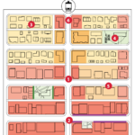
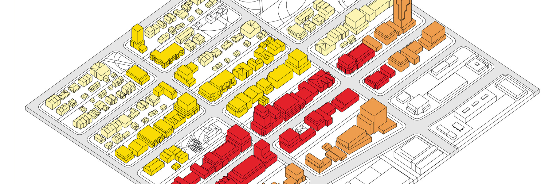
Map 3: Urban Form Categories

Map 4: Building Scale
FAQs
The "sense of place" inherent in a neighbourhood is a function of its history, buildings, natural features, landscape and people. Together, the interaction of these elements defines the distinctive identity and local character of a neighbourhood. A sense of place is known by experience. Residents living in a community actively use spaces to create a sense of place. The feeling of belonging to a community is created through familiar, everyday social interactions within a localized setting. Neighbourhood identity is expressed as a sense of belonging amongst residents that share a sense of place.
In planning terms, neighbourhood character is shaped by design elements that unify the look and feel of an area. These elements can be referred to in community-based planning policies or local policies. Patterns of streetscape are established through repeated setbacks, the placement of garages and landscaping, for example. Building forms can have similar heights and massing (lot coverage), roof pitch, dormers, window placement, and porches. The choice of materials can also be a unifying element. By creating an area plan that guides future development, community-specific policies can help ensure that new development is sympathetically integrated with existing buildings.
The coordination between top-down planning and bottom-up community perspectives is what makes great "place-based" planning. The demographic profile, character, and needs of communities vary substantially between neighbourhoods. This diversity creates unique places that require context-specific planning policies. Place-based planning begins with listening to the needs and the objectives of residents living in a neighbourhood. No one understands the challenges and opportunities of a place better than those who live and work there. A place-based approach means all government departments focus on the outcomes of a place rather than on individual projects. It privileges the needs of residents over the profits of non-owner property investors.
All the elements that make up the physical environment of a street and define its character. These elements include paving, sidewalks, trees and vegetation, lighting, building type, fencing, setback of buildings, etc. Historic streetscapes have garnered significant attention lately, with the approval of heritage policies to protect historic streetscapes in July 2020. Within part 4, see heritage area policy for historic residential streetscapes.
Main streets are often considered to be the principal streets of a town where shops, restaurants and other businesses are found. Main streets have historically developed along streetcar lines and then auto-oriented roadways. Calgary's Municipal Development Plan provides guidance for the development of main streets. The highest densities and tallest buildings on the main street should be concentrated into "nodes" that occur at the intersections of the main street with other major transit streets.
In encouraging the growth of a more compact city, Calgary's Municipal Development Plan (MDP) guides the highest density towards mixed-use, transit-supported main streets and activity centres. Currently, Calgary's primary activity centre is the Downtown. The MDP encourages the strategic placement of other activity centres that will support long-term employment and population growth in locations served by high-frequency transit services.
A local area plan guides where and how future growth and redevelopment should happen within a specific area. Calgary's new multi-community approach is to create one local area plan for groupings of 10 to 15 communities. This approach would help reduce the number of about 270 existing and possible "Area Redevelopment Plans" to approx. 42 multi-community area plans. A simplified framework allows area plans to be kept up-to-date using a common set of policies that support the growth of a more compact city.
In an effort to increase population in developed Calgary, the City is changing its rules for adding new development. Urban form categories create designations to allow for multi-unit, mixed-use buildings (commercial & residential) in the creation of local area plans. Neighbourhood urban form categories include: commercial required (where commercial uses should be offered on the ground floor); active (a mix of commercial and residential with high pedestrian activity); general (supporting a broad range of housing types and some small-to-moderate commercial uses); and local (a broad range of housing types and home-based businesses with strong private-public separation).
The current Land Use Bylaw in Calgary assigns a “district” (zone) to land parcels with permitted and discretionary uses. This approach to development is called “use-based” planning. Calgary’s land use bylaw distinguishes between residential, commercial, and industrial categories. Separate districts are defined for low-density residential, including: single-detached housing (R1, RC-1), duplexes (R2), and row houses (R-CG). These districts offer clarity and predictability to the planning process, giving citizens some assurance about what will be allowed where. The districts also attribute differences in building height and lot coverage that have impacts for overshadowing and massing, especially significant in historic neighbourhoods with older buildings. Currently, re-designations must go to a Public Hearing of Council that allows residents to comment on the impacts of new development in their neighbourhoods.
The urban form categories proposed for local area planning provide the foundation for a new bylaw that combines low-density housing forms into a new “district” or set of “districts.” If the new bylaw is adopted, to be considered in 2021, this will signal a shift towards “form-based” development, where physical form rather than the separation of uses becomes the organizing principle. The City would be able to implement its growth strategy more quickly. More diverse building types would be allowed without the need for public comment on the introduction of multi-unit and multi-use (commercial & residential) buildings in neighbourhoods.
A secondary suite is self-contained anywhere within the main home (often the basement) but secondary to it (smaller). A backyard suite must be smaller than the main house and be contained in a detached building behind the front façade of the main residential building. Examples are a suite located above a garage or a separate “laneway” or “garden” house. Legal suites contain 2 or more rooms designed to be used as a residence by one or more persons. Suites must have a kitchen, living, sleeping and sanitary facilities, and one parking stall on the parcel. They must meet all building codes for safety and construction and have passed inspection. Secondary and backyard suites do not have a separate title and cannot be sold independently of the main home. They can be rented out, owner-occupied, or occupied by other person(s) like a family member or caregiver.
Designated heritage homes may be eligible for the City’s Historic Resource Conservation matching grant program to help with retrofitting costs and all homes listed on the Inventory of Evaluated Historic Resources may be considered for parking bylaw relaxations, if parking for tenants can’t be accommodated on site. The City continues to update its tools and incentives to accommodate suites and retain heritage.

Density Bonusing
Adaptive Reuse and Heritage Density Transfer
Balancing heritage conservation with the necessary renewal of aging buildings and infrastructure, all while accommodating growth, is challenging indeed! Often our smaller to medium scale heritage buildings are located on corridors and commercial streets where market demand for redevelopment is greatest. These buildings may once have been used for a purpose no longer needed in the inner-city. A warehouse might become apartment lofts, school rooms could convert to offices, or a factory might be transformed into an event space. This is called adaptive reuse. Explore some of Calgary’s great “New Uses for Old Buildings” here.
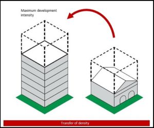
One incentive to retain heritage in redevelopment is called “heritage density transfer or bonusing”. If an owner opts to retain and designate a heritage resource, they may transfer (sell) the undeveloped potential of their site to allow another property to exceed the allowable density specified by the zoning requirements of the land use by- law. Think of the empty air space above a 3-storey heritage building that could have a 12-storey building erected on the site if the heritage building were demolished. That unused density could be transferred (sold) to allow a new building nearby to exceed the-12 story maximum allowed by the land use bylaw. So the two sites together achieve the maximum density for the combined parcels. The owner of the heritage building receives a financial benefit from the potential of their property without needing to demolish it in order to realize that gain.
The specifics of the density transfer can be negotiated between the City and developer. For example, The Arriva condo building in Victoria Park became the tallest residential building in Alberta when it was completed in 2007 because the developer committed to restore and preserve the Victoria Park School, which occupies the same site. Completed in 1912, it was one of the many schools built to accommodate Calgary’s rapidly growing population during the city’s pre-World War I boom. The Edwardian architecture is typical of the historic Paskapopo sandstone schools found among Calgary’s older neighbourhoods. The juxtaposition of the Victoria Park School against the towering condos reminds us of Calgary’s past and present.
A local area plan, such as some existing Area Redevelopment Plans (ARP) or the new multi-community Local Area Plans may include density bonusing policies for specific areas. A formula for calculating the amount of the bonus should be established at the time of plan development, as would the use of the contribution. For example, it could be applied to a community investment fund, ideally to protect local heritage, especially where an undesignated but inventoried heritage resource is demolished. A fundamental principle of density bonusing in Calgary is that the area receiving the additional density should also be the area receiving the amenity benefit. It is therefore important that the LAP process, with resident input, identify eligible buildings for preservation, ensure that the appropriate level of bonusing is in place given the target density to be achieved, and that the intended use of the bonus is established.
In Fall of 2020, The City of Calgary approved a $1 million, cost shared, non-residential Historic Resource Conservation Grant in 2021 and 2022 with annual base funding to be increased to $2 million in 2023 and beyond. This grant may be available to owners of designated heritage resources, with specified limits. The grant covers some of the costs associated with restoration and adaptive reuse. Often, the revenue potential of the site could be greater if the heritage resource was demolished and the site was redeveloped to the maximum allowed by the land use by-law.
The City is currently reviewing funding tools and investment strategies that will support evolution and change in our communities.
Generally, density transfer/bonusing is not appropriate for low density residential neighbourhoods. For example, communities are not likely to support high density infills next to a designated single-detached home because of the impact on the streetscape.
Learn more:

